Costa Rica
    real estate intelligence

    Check any property in minutes.

    The complete record on any Costa Rican property, straight from official registries.

    Ownership·Liens·Taxes·Zoning·Water rights·Road access·Cadastral plans·Fiscal valuation·Boundaries·Neighbouring parcels·Protected areas·Points of interest·
    2.1M+ properties
    40+ sources
    Nationwide

    How it works

    01

    Find the parcel

    Search an address, paste a Google Maps link, enter coordinates or a property number, or tap the parcel on the map.

    02

    We query the registries

    Every record comes directly from the official registries, fetched the moment you order.

    03

    Receive the report

    A PDF and a web report with every finding explained. Usually ready in 2 minutes.

    What's in the report

    Every report compiles the official records of one parcel into a single document. The excerpts below come from real reports.

    Read a complete example report

    Risk summary

    The report opens with a clear rating and every finding in plain language: what was found, why it matters, and what to do about it.
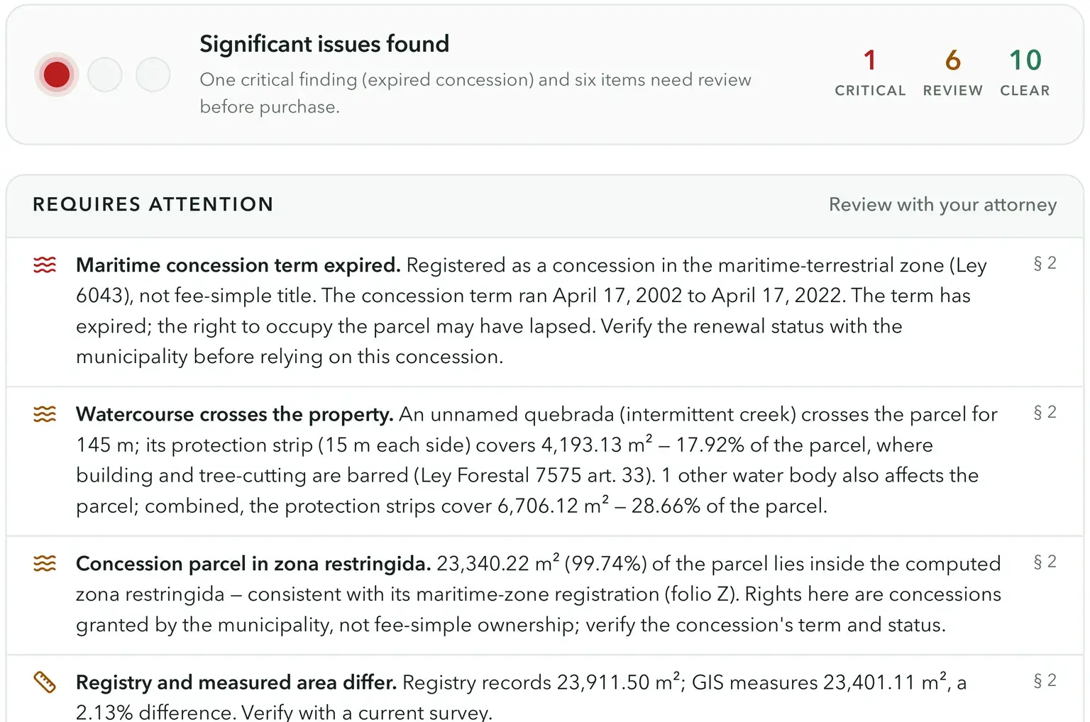
    Report risk summary: significant issues found, one critical finding and six to review, with findings explained in plain language

    At a glance

    One page with the key facts and the status of every check: property number, plan, area, fiscal value, owners, encumbrances, access, zoning, water, and taxes.

    At-a-glance fact sheet with property number, area, location, fiscal value, and the status of each check

    Neighbouring parcels & overlaps

    The parcel among its neighbours in the cadastre, on satellite imagery. Overlapping parcels and newly filed survey plans are measured and flagged.

    Satellite map of the parcel among its labelled neighbours, with a flagged parcel highlighted, and the adjacent-parcels table

    Road access

    Public road frontage confirmed against the national road network on satellite imagery, with the computed frontage — plus registered access easements (servidumbres) when the parcel depends on one. A parcel without legal access is flagged as critical.

    Satellite map of the declared public roads (RedVial) around the parcel, drawn as red road surfaces with the frontage stretch highlighted
    Road access overview confirming an adjacent mapped public road with computed frontage

    Maritime zone (ZMT)

    For coastal parcels, the official ZMT demarcation on satellite imagery: the mojón markers and zona-pública boundary, the computed 150 m zona restringida, and how much of the parcel falls inside.

    ZMT demarcation map: the mojón line along the beach, the zona restringida band with the parcel area inside it filled orange, and the landward ZMT limit

    Protected areas

    The parcel is checked against SINAC's registry of national parks, reserves, and refuges. Any overlap is mapped and measured; overlap with a state-owned category can bar private titling.

    Protected-area check: most of the parcel lies inside a state-owned absolute natural reserve — the reserve interior tinted amber on the satellite map, the parcel area inside it filled red

    Bodies of water

    Rivers, quebradas, and lakes from the national hydrography, with their statutory protection strips. The report measures how much of the parcel is affected; building inside the strips is prohibited.

    Satellite map with the quebrada and its protection strip; the affected area inside the parcel is filled orange
    Water-body check: a quebrada crossing the parcel, with the protection strip and affected area measured

    Wells & water concessions

    Registered wells and water concessions on and near the parcel, with each well's protection perimeter and what it means for drilling and building permits.

    Satellite map of registered wells: one concession on the parcel and two nearby, with operational setbacks and interference bands
    Concession card with holder, file number, status, and expiry

    Owners and their rights

    Every registered owner with their identification, type of right, and share: full ownership, fractional shares, bare ownership, and usufruct. A transfer requires every right-holder to sign.

    Owner cards for an inherited parcel: a one-sixth bare-ownership share and the holder of the usufruct

    Liens & encumbrances

    Mortgages, embargoes, easements, and other charges registered against the title, each explained in plain terms, together with court and administrative annotations.

    Encumbrance cards: an expired maritime concession term and an active legal restriction, each with citation and dates

    Registry movements

    Every act registered against the property since 1994: transfers, mortgages constituted and cancelled, subdivisions, and the parcel's lineage from its mother finca.

    Ownership transfers table with two donations, followed by dated registry movements — mortgages constituted and cancelled — translated with the original Spanish act names

    Zoning & land use

    The canton's plan regulador and the parcel's zone with its building rules: permitted uses, coverage, height, setbacks, minimum lot size.

    Zone card for Zona Residencial de Baja Densidad: minimum lot 600 m², coverage 50%, height 7 m, setbacks, and density
    Plan regulador status: in force, approved 2006, covering the whole canton

    Municipal taxes & valuation

    The declared fiscal value, the annual canon on a concession, the luxury-home-tax check, and the payment status of every municipal charge, including overdue balances.

    Concession canon estimate: rate, fiscal value, and the annual canon amount
    Municipal tax status with an overdue balance, charges by year, and a note that unpaid taxes transfer with the property

    Points of interest

    Supermarkets, schools, medical facilities, banks, and beaches near the parcel, with distances and ratings, summarized in an amenity score.

    Maps of nearby supermarkets, schools, medical facilities, and banks with numbered markers

    Cadastral plan

    The registered survey (plano catastrado) with its number, date, surveyed area, and the scanned plan itself.

    Scanned plano catastrado: the official land survey with bearings, distances, and registry stamps

    Read a complete report

    The full example report for a coastal finca: every check above, exactly as delivered.

    Open the example report

    Built for everyone in the deal

    Buyers & sellers

    Verify ownership, liens, and boundaries before you commit.

    Real estate agents

    Hand clients instant, data-backed due diligence and close faster.

    Attorneys & notaries

    Replace hours of registry research with source-verified reports.

    One report, one credit

    Buy credits in bulk and save.

    Common questions

    PropScan provides data in real time from Costa Rica's SIRI cadastral system, the Registro Nacional de la Propiedad, municipal tax authorities, and the national water concession registry.

    Every report queries official registries at the time of generation, so you always get the latest available data.

    PropScan reports contain official data sourced directly from government registries, delivered as professional PDFs suitable for legal review, client presentations, and due diligence files. That said, PropScan can not guarantee and can not be held liable for the accuracy of the information presented — any legal and final action to acquire a property should be performed with the help and under the guidance of an experienced attorney.

    Most reports are ready within a few minutes. The exact time depends on the responsiveness of the government registries being queried.

    Generating one report costs one credit. Check our pricing section above for current credit packages, bulk discounts and subscriptions.

    If we can't compile a complete report, your credit is returned automatically. You're only charged for complete reports.

    You can search by address, paste a Google Maps or Waze link, enter GPS coordinates, type a property number (finca), or simply click anywhere on the marked areas of the map.

    Reports are informational and not a substitute for legal advice.

    Ready to know what you're buying?

    Search any property and order its report in minutes.

    Not ready yet? Read an example report first.